Environmental Surveys

Habitat Mapping and Monitoring

High-Resolution Habitat Mapping and Monitoring

Our drones are equipped with advanced imaging technology that captures high-resolution aerial images. This capability is essential for

  • Mapping Habitats We create detailed maps of various habitats, providing a clear overview of their structure and extent.
  • Monitoring Changes Over Time Regular drone surveys help track changes in habitats, allowing for early detection of potential issues and informed decision-making.

These services are crucial for understanding ecosystems, tracking wildlife populations, and managing conservation efforts effectively. Our high-resolution data enables precise analysis, ensuring that conservation strategies are based on accurate and up-to-date information.

Forestry and Vegetation Analysis

Forest Health Assessment

Our drones capture high-resolution multispectral images, providing detailed information on vegetation health. By analyzing these images, we can identify areas affected by diseases, pests, or environmental stressors, allowing for timely interventions.

Monitoring Tree Growth

With our drone services, continuous monitoring of tree growth becomes efficient and accurate. High-resolution imagery and data collected over time enable us to track growth patterns, detect anomalies, and ensure sustainable forest management.

Disease and Pest Detection

Drones equipped with thermal cameras can detect subtle changes in tree temperature, which often indicate the presence of diseases or pests. Early detection allows for prompt action to mitigate damage and preserve forest health.

Water Resource Management

Water Quality Monitoring

Drones equipped with advanced sensors and cameras are capable of assessing various water quality parameters. These include:

  • Temperature: Thermal sensors detect temperature variations in water bodies.
  • PH Levels: Specialized sensors measure the acidity or alkalinity of water.
  • Turbidity: High-resolution cameras assess water clarity by detecting the presence of suspended particles.
  • Chemical Contaminants: Drones can identify pollutants such as heavy metals, nitrates, and phosphates through spectral analysis.

Regular monitoring helps in maintaining water safety standards and addressing contamination issues promptly.

Depth Measurement

Using sonar and LiDAR technology, drones can accurately measure the depth of water bodies. This data is crucial for:

  • Navigational Charts Providing accurate and up-to-date information for safe navigation.
  • Sediment Analysis Understanding sediment accumulation patterns for dredging purposes.
  • Habitat Studies Assessing the aquatic environment to support marine life research and conservation efforts.

Depth measurement via drones is faster and safer compared to traditional methods.

Pollutant Detection

Drones play a vital role in detecting pollutants in water bodies. Equipped with multispectral and hyperspectral sensors, they can

  • Identify Oil Spills Detecting the presence and extent of oil contamination.
  • Chemical Spills Spotting areas affected by chemical spills from industrial discharges.
  • Nutrient Loads Measuring levels of nitrogen and phosphorus that contribute to algal blooms.

Early detection of pollutants helps in mitigating environmental damage and implementing corrective measures swiftly.

Irrigation System Management and Flood Risk Assessment

Drones are invaluable for managing irrigation systems and assessing flood risks through

  • Irrigation Audits: Monitoring the distribution and efficiency of irrigation systems to optimize water usage and enhance crop yields.
  • Flood Mapping Creating detailed topographic maps to predict flood-prone areas.
  • Flood MonitoringProviding real-time data during flood events to support emergency response and evacuation planning.
  • Erosion Control Monitoring riverbanks and coastal areas to identify erosion patterns and implement preventive measures.

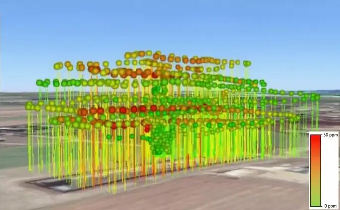
Soil and Land Degradation

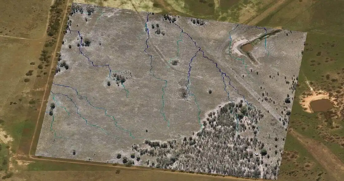
By capturing detailed topographic data, drones provide precise information on soil erosion patterns. This data is essential for understanding how soil is being displaced over time, identifying vulnerable areas, and implementing effective erosion control measures. With high-resolution imagery and 3D models, we can monitor erosion rates and devise strategies to prevent further degradation.

Land Degradation Monitoring

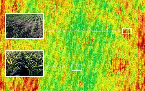
Drones are instrumental in assessing land degradation, which includes loss of vegetation, soil fertility, and biodiversity. Through aerial surveys, drones can map degraded areas, track changes over time, and provide insights into the causes of degradation. This information is crucial for developing targeted restoration plans and evaluating the effectiveness of land management practices.

Desertification Processes

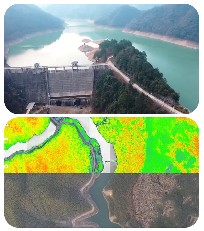
In regions prone to desertification, drones offer a reliable method for monitoring changes in land cover and vegetation health. By analyzing multispectral and thermal images, drones help in detecting early signs of desertification, such as reduced vegetation cover and increased soil exposure. This enables timely interventions to combat desertification and restore affected areas.

Land Restoration Projects

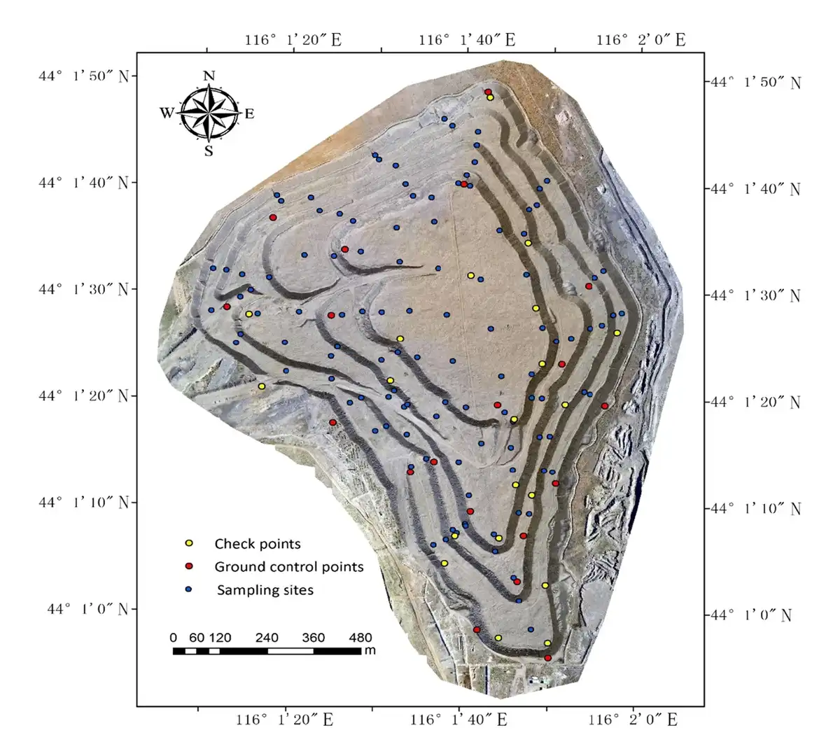
For land restoration projects, drones play a vital role in planning and monitoring. They provide accurate data on current land conditions, helping to identify areas that need intervention. Throughout the restoration process, drones can track progress, assess the impact of restoration efforts, and ensure that objectives are being met. This continuous monitoring ensures the success and sustainability of restoration projects.

Air Quality Monitoring

Our Environmental Survey services utilize advanced drone technology equipped with state-of-the-art sensors capable of measuring crucial air quality parameters. These include

Particulate Matter (PM) Detection

  • Drones equipped with particulate matter sensors can accurately measure PM1, PM2.5, and PM10 levels in the atmosphere. This data is vital for assessing air pollution levels and understanding health risks associated with fine particulate matter.

CO2 and Gas Monitoring

  • Our drones are equipped with sensors to measure carbon dioxide (CO2) levels and other gases such as methane (CH4), nitrogen dioxide (NO2), sulfur dioxide (SO2), and ozone (O3). This comprehensive monitoring helps in evaluating greenhouse gas emissions and air quality compliance.

Environmental Pollutant Assessment

  • They can detect various pollutants, including volatile organic compounds (VOCs), airborne toxins, and industrial emissions. This capability is essential for identifying sources of pollution and ensuring regulatory compliance.

Real-Time Data Collection

  • With the ability to cover large areas swiftly, our drones provide real-time data on air quality parameters. This enables prompt decision-making for environmental management and emergency response operations.

Our Features

5x Faster Delivery

Our dedicated team of GIS experts works tirelessly to swiftly process and analyze drone survey data, ensuring prompt delivery, often ahead of schedule.

99% Accurate Measurement

We achieve up to 99% accuracy in our results, employing advanced machine learning techniques for precise yield estimation, volumetric measurements, and more.

Team of Experts

Our seasoned team of GIS engineers, drone pilots, and software engineers operates round-the-clock, delivering unparalleled service excellence.

Advanced Equipment

Equipped with cutting-edge drones featuring high-resolution sensors, our surveying capabilities are bolstered by both DJI models and custom-made drones.