Highways And Roadways
We offer a range of valuable services in the pre-construction phase of highway development, providing efficient data collection, analysis, and monitoring capabilities. Here are some of the key services we can offer:
Detailed Project Report (DPR)
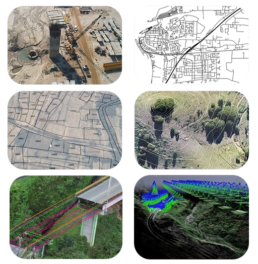
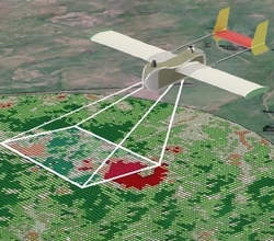
Drones equipped with high-resolution cameras and LiDAR (Light Detection and Ranging) sensors can quickly survey large areas to create detailed topographic maps and 3D models. This data helps engineers and planners understand the terrain, identify potential obstacles, and plan the highway route more accurately.
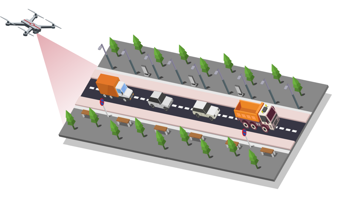
Drones can conduct regular site inspections to monitor progress, identify potential safety hazards, and ensure compliance with design specifications. They can capture high-definition images and videos of the construction site from various angles, providing valuable visual documentation for project stakeholders.
By flying over construction sites, drones can track earthmoving activities, measure stockpile volumes, and monitor cut and fill operations. This data helps project managers optimize resource allocation, track progress, and detect deviations from the project schedule
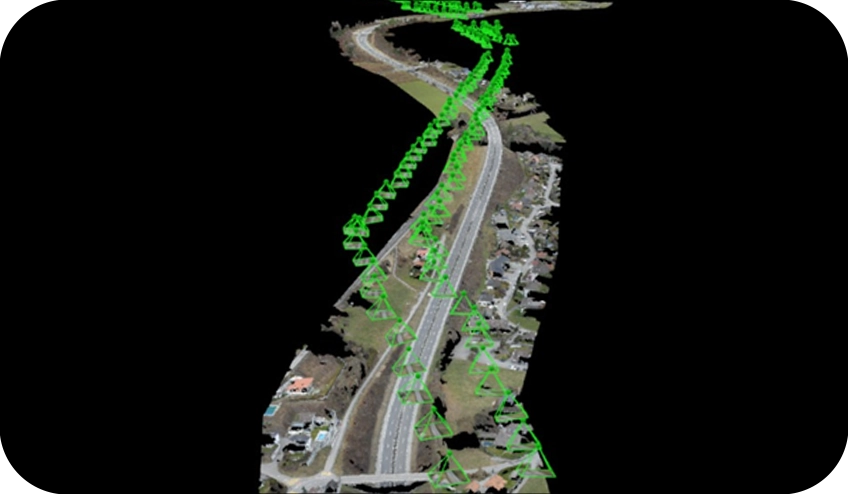
DATA PKT assists its clients in selecting from among the various proposed routes the best alignment from point A to point B, connecting cities, populations, and industries. We collect site information using UAVs and convert it into othomosaic maps, digital elevation models and contours, which help check and resolve conflict with proposed and existing structures. We digitize the revenue map and estimate the cost of land and analyse the expenditure of the construction with the stockpile volume, obstacles , ground feature measurement and estimated circles rates to offer a cost efficient way to construct a highway.
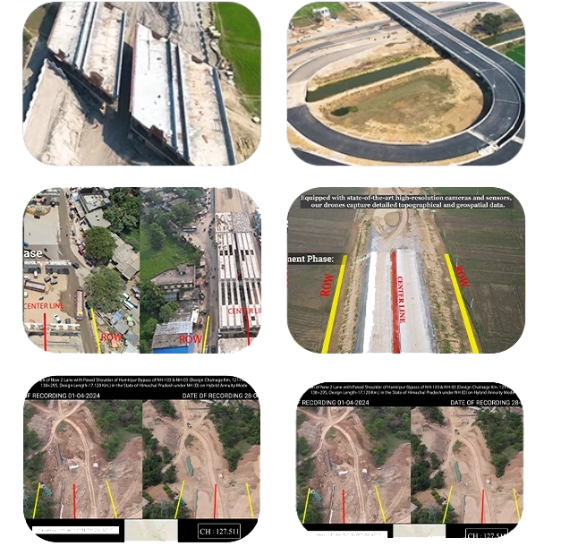
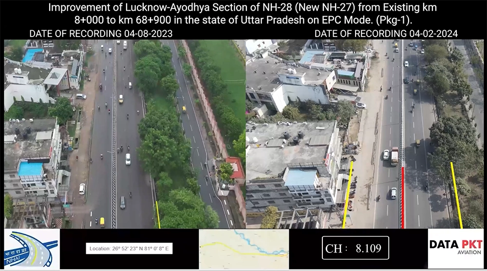
We capture and process the raw drone images to generate orthophotos, which are geometrically corrected and distortion-free images of the construction site. We use photogrammetry software to stitch together the images and create orthophotos with high accuracy and resolution. Compare orthophotos captured at different time points to identify changes and progress in the construction work and determine the work completion percentage and expected time of work completion.
Drones from DATA PKT capture aerial photogrammetric data once each month and generate a customised video project report with key project completion rates and site surveillance information. Monthly comparative reports are also provided to assist in detecting new encroachments and buildings being developed on the site.
l surveys to capture detailed images of the construction site, focusing on areas where utility lines are being relocated or adjusted. Analyze the drone imagery to track the progress of utility shifting, ensuring compliance with project timelines and minimizing disruptions to services. Identify any potential conflicts or safety hazards arising from utility relocations and promptly address them to prevent delays and accidents. Generate comprehensive reports documenting the status of utility shifting activities and facilitating coordination between construction teams and utility providers for efficient project management.
Drone-generated electronic records are exceedingly accurate and of high quality. It acts as trustworthy proof for highway construction businesses to receive prompt reimbursement from the government and insurance companies in the event of a review.
To boost transparency and consistency and make use of cutting-edge technology, the National Highways Authority of India (NHAI), which falls under the ministry of Road, Transport, and Highways.
Road laying alone does not mark the end of a highway construction process; rather, it is the beginning of a continuous process that necessitates ongoing operations and maintenance. The following services are provided by DATA PKT to its clients to assist them in maintaining their assets:
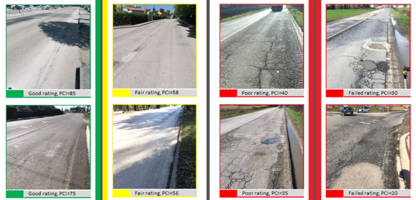
Drones from DATA PKT gather high-quality aerial data and convert it into 3D point clouds to aid in mapping roads in need of repair. Our image processing software uses this for pothole detection and encroachment identification using comparative monthly video project reports. The prompt discovery of any abnormalities after the construction of roadways and highways aids in the protection of lives that might otherwise be lost due to unsafe road conditions.
We capture high-resolution aerial images of highway right-of-way areas. Conduct regular flights to monitor for encroachments such as illegal structures, vegetation overgrowth, or unauthorized activities. Analyze the drone imagery to identify encroachments and assess their extent and impact on highway safety and functionality. Generate detailed encroachment reports with annotated images to document findings and inform appropriate authorities for corrective action. Utilize this proactive approach to maintain the integrity of highway right-of-way and ensure compliance with legal regulations.
Corridor mapping with our UAV services revolutionises data capture along linear features. We offer cost-effective, efficient, and precise mapping solutions. From flight planning to data processing, we provide high-resolution imagery for diverse applications like transportation planning, asset management, and emergency response. This streamlined approach enhances safety, reduces costs, and enables informed decision-making. With ongoing advancements, UAV technology promises continued growth and valuable insights for infrastructure management.

Through DATA PKT's meticulous cost-benefit analysis, highway construction companies gain invaluable insights that revolutionize their approach to maintenance and repair projects. By providing precise cost estimations for restoration work, businesses can proactively plan and budget for necessary maintenance, thereby minimizing unexpected expenses and optimizing resource allocation.
Moreover, the early detection of potential issues enables companies to implement preventative maintenance strategies, mitigating the risk of more extensive damage and costly repairs in the future. When addressing potholes, DATA PKT's analysis facilitates the accurate computation of cut-and-fill volumetric measures, allowing companies to optimize material usage and minimize waste, leading to significant cost savings. This comprehensive approach empowers highway construction companies to enhance operational efficiency, reduce expenditure, and deliver high-quality infrastructure that meets the needs of both businesses and communities.
DATA PKT's analysis facilitates the accurate computation of cut-and-fill volumetric measures, allowing companies to optimize material usage and minimize waste, leading to significant cost savings. This comprehensive approach empowers highway construction companies to enhance operational efficiency, reduce expenditure, and deliver high-quality infrastructure that meets the needs of both businesses and communities.
DATA PKT's comprehensive cost-benefit analysis represents a transformative tool for highway construction companies, providing them with a robust framework for precise cost estimation and strategic planning in infrastructure maintenance. Leveraging advanced data analytics and predictive modeling, DATA PKT empowers these companies to proactively implement preventative maintenance initiatives, effectively mitigating potential risks and minimizing the need for costly repairs. Through thorough examination of historical data, real-time information, and predictive algorithms, DATA PKT furnishes accurate forecasts of the costs associated with restoration work, enabling efficient resource allocation and the implementation of targeted maintenance strategies that optimize cost-effectiveness and infrastructure longevity. Furthermore, DATA PKT's analytical capabilities extend to the computation of cut-and-fill volumetric measures during pothole repair operations, offering invaluable insights into material usage optimization and waste reduction.
This comprehensive approach not only yields significant cost savings but also enhances operational efficiency, improves road safety, and fosters sustainable infrastructure management practices. By leveraging the advanced analytical tools provided by DATA PKT, highway construction companies can catalyze a paradigm shift in their maintenance approach, ensuring the sustained reliability and resilience of transportation networks while delivering tangible economic and social benefits to communities nationwide.
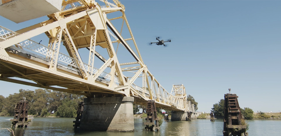
The dynamic nature of our cutting-edge drone technology revolutionizes the way engineers assess bridges, offering unparalleled versatility and comprehensive insights into their structural integrity and condition. These advanced drones can navigate and inspect bridges from every conceivable angle and perspective, providing engineers with a holistic view of their performance and potential vulnerabilities. By leveraging their small size and swift movement capabilities, drones have become indispensable tools for inspecting and surveying remote areas, where traditional methods would be impractical or unsafe.
Equipped with high-resolution cameras and state-of-the-art sensors, these drones capture sharp, detailed photos, and videos that offer a wealth of valuable information for engineers and infrastructure managers. From capturing close-up shots of intricate bridge components to providing sweeping panoramic views of entire structures, drones deliver visual data that enhances the accuracy and efficiency of bridge inspections. Moreover, their ability to access hard-to-reach areas ensures that no aspect of bridge infrastructure goes unchecked, enabling engineers to identify potential issues and address them proactively. By harnessing the power of drone technology, engineers can optimize maintenance strategies, prioritize repairs, and ensure the safety and longevity of critical transportation infrastructure for years to come.
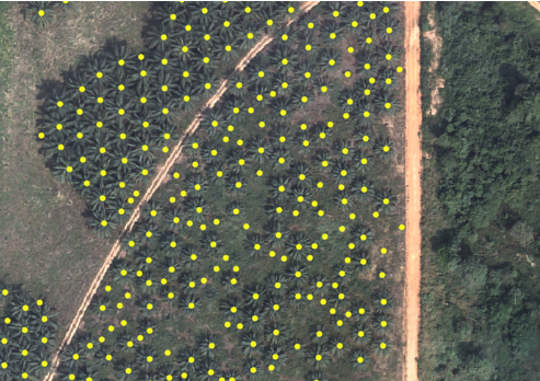
Incorporate drones equipped with cutting-edge aerial imaging capabilities into the post-construction phase of the highway project to conduct a thorough survey of the surrounding area. Capture high-resolution images encompassing the entire vicinity to provide detailed coverage for accurately counting and mapping existing trees. Utilize advanced image processing techniques to analyze the drone imagery and precisely identify suitable locations for tree plantation along the highway corridor, considering factors such as soil quality, sunlight exposure, and proximity to water sources. This meticulous analysis ensures the identification of optimal sites that will foster the growth and sustainability of newly planted trees.
Furthermore, generate comprehensive reports that outline the tree count, species distribution, and proposed plantation sites, providing stakeholders with valuable insights to facilitate informed decision-making and prioritize environmental stewardship initiatives. By implementing proactive measures to enhance green infrastructure and biodiversity, the project can mitigate the environmental impact of highway construction and contribute to the long-term sustainability of the surrounding ecosystem.
DPR offers comprehensive services like surveying, site inspection, earthwork monitoring, and best route analysis, optimizing highway construction for longevity, cost-effectiveness, and sustainability, ensuring efficient project management and high-quality infrastructure development.
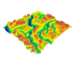
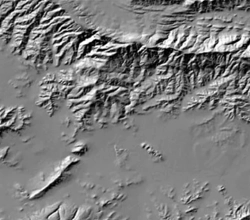
DTM's (Digital Terrain Model) are detected using aerial photography at low heights with a geometrically calibrated camera. This enables the drone to obtain all heights of a surveyed terrain.Generating Digital Terrain Models (DTM) for highways with drones provides detailed elevation data essential for accurate design and construction planning.
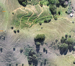
Drone data enables accurate contour mapping for highways, providing essential topographic insights for efficient road design and construction. This technology streamlines the process, enhancing project planning and execution while ensuring optimal route alignment and drainage management.
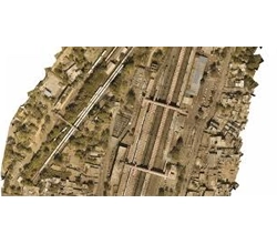
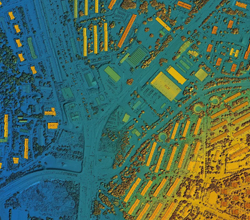
we create orthomosaic for highway construction using drone-captured aerial imagery stitched together using photogrammetry software for comprehensive site visualization and analysis.Orthomosaic imagery from drones enhances highway construction by providing detailed, accurate visual data for planning, monitoring, and quality assurance.
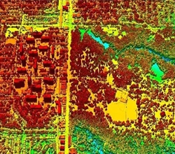
DSMs capture both natural and built features on Earth's surface, making them invaluable in urban planning for comprehensive spatial analysis. Their representation of above-ground features aids in effective land-use planning and infrastructure development for sustainable urban environments.
Aerial photogrammetry and videography improve highway projects with detailed imagery for planning, monitoring, and documentation. This enhances project efficiency and accuracy, ensuring better decision-making and streamlined documentation processes.
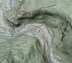
Utilizing drones for topographical surveys in highway construction provides efficient, high-resolution mapping, facilitating precise terrain analysis and design optimization. This approach enhances project planning and execution, ensuring optimal infrastructure development and resource utilization.
DEM (Digital Elevation Model) data aids in highway planning and design by providing accurate topographic information, enabling efficient alignment and gradient analysis. Integrating DEM into GIS allows for comprehensive visualization and analysis, enhancing decision-making in highway engineering projects.
LIDAR surveys for highways yield detailed topographic data crucial for precise route planning, infrastructure design, and safety assessment. This information guarantees the implementation of optimal construction and maintenance practices, enhancing overall efficiency and safety standards.
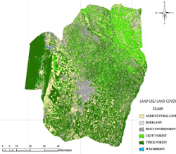
Highway land use and cover mapping offers critical insights for infrastructure planning and environmental management, aiding in sustainable development and efficient resource allocation, essential for responsible resource usage and ecosystem preservation.
Already covered 65000+ KM of Highway in a short time span of 3 years and helped project managers and authorities to ensure accountabilty & increase efficiency.
With experienced Pliots, GIS engineers & high-end Survey Drones, we can easily scale up to cover 100 KM of Highway & Roads a day.
We have team of GIS expert working around clock to process and analyse the Drone survey data to deliver on or before time.
70% more accurate data than the traditional survey